The Illinois River carves through Peoria, leaving a subsurface far more complex than the flat prairie suggests. Beneath the glacial till and loess that blanket the region, the underlying St. Louis and Salem limestone formations are prone to solution cavities and irregular weathering. This is precisely where seismic tomography becomes a critical reconnaissance tool. Whether for a commercial development near the Warehouse District or a bridge abutment along the riverfront, mapping the transition from soft sediments to competent bedrock dictates foundation economics. We apply both refraction and reflection techniques to deliver continuous velocity profiles, tying results directly to IBC Site Class definitions. When you need to know if that high-resistivity anomaly on the ERT survey is a void or a boulder, seismic velocity provides the discriminating data. Complementing this with a MASW survey provides the 30-meter shear-wave velocity (Vs30) required for ASCE 7 seismic design, while targeted SPT drilling at anomaly locations converts the geophysical interpretation into a geotechnical parameter the structural engineer can use with confidence.
Seismic velocity is the one geophysical property that directly informs both material stiffness and IBC Site Class without empirical conversion factors.
Our approach and scope
A recent project on the bluffs overlooking the Illinois River illustrates the value of integrated geophysics. The developer planned a multi-story structure, but borings on the east side of the lot encountered limestone at 12 feet while the west side showed 45 feet of clay and sand. A 24-channel seismic refraction survey with 5-meter geophone spacing revealed a buried paleochannel carved into the bedrock, its steep banks hidden by glacial drift. The velocity contrast between the channel fill (Vp ~900 m/s) and the limestone (Vp >2,500 m/s) was unmistakable. This kind of subsurface geometry, invisible to a standard boring grid, would have led to severe differential settlement across the mat foundation. By combining the seismic tomography with CPT soundings inside the channel, we defined the soil behavior type without additional disturbed sampling. The structural engineer then redesigned the foundation as a combination of shallow footings on the rock side and a deep pile group on the channel side, relying on the velocity data to estimate pile refusal depths before a single rig mobilized.
Local geotechnical context
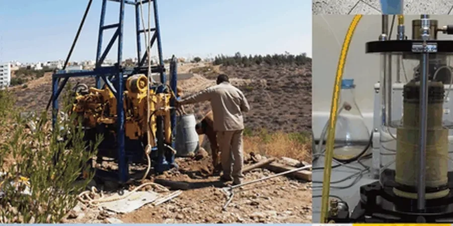
The seismic source for deep refraction work in Peoria often involves an accelerated weight drop mounted on a trailer, capable of generating a repeatable 200 kg impact across a 1 m² aluminum plate. For shallower reflection surveys, a simple sledgehammer strike on an aluminum plate provides sufficient energy above 100 Hz to image horizons within the upper 30 meters. The 24-channel seismograph records the full waveform at each geophone, and our processing software picks first arrivals on every trace. The risk we mitigate is interpretation bias. A low-velocity layer hidden beneath a high-velocity cap—a classic scenario in Peoria where dense glacial till overlies softer, saturated outwash sand—will be invisible to standard refraction interpretation. We run reciprocal time checks on every shot record and apply tomographic inversion algorithms that do not assume a layered earth. This catches the hidden layer before it becomes a construction surprise. On sites within the Illinois River floodplain, we also encounter gas-charged organic silts that attenuate high-frequency energy, forcing us to adjust source effort and geophone spacing to maintain resolution at depth.
Relevant standards
ASTM D5777 – Standard Guide for Using the Seismic Refraction Method, ASCE 7-22 – Minimum Design Loads for Buildings; Chapter 20, Site Classification Procedure, IBC 2021 – Section 1613, Seismic Ground Motion Values and Site Coefficients, ASTM D7400 – Standard Test Methods for Downhole Seismic Testing (for Vs calibration)
Quick answers
What depth can seismic refraction reach in the Peoria area?
In the glacial deposits around Peoria, a 115-meter spread length typically images to depths of 20 to 25 meters for continuous velocity coverage. Penetration depends on the velocity structure: the stiff glacial till overlying limestone transmits energy efficiently, so we often reach the bedrock interface even when it lies at 30 meters. If the target is deeper, we extend the spread or switch to reflection methods.
Can seismic tomography detect sinkholes and caves in the limestone?
Yes, but with important caveats. A solution cavity filled with air has a strong velocity contrast (Vp drops from >2,500 m/s in limestone to ~340 m/s in air) and produces a clear low-velocity anomaly on the tomogram. However, a clay-filled cavity has a velocity similar to the surrounding weathered rock, making it less distinct. We typically combine seismic refraction with electrical resistivity tomography on karst-prone sites to cross-validate anomalies.
How much does a seismic refraction survey cost in Peoria?
A typical refraction survey with 24-channel recording over a 115-meter line, including mobilization, data acquisition, processing, and a signed report with velocity cross-sections, ranges from US$2,470 to US$5,630 depending on site access, number of lines, and source type required. Multiple adjacent lines reduce the per-line cost due to shared mobilization.
Is seismic tomography accepted by Peoria building departments for site classification?
Yes. The IBC, adopted by Peoria and the state of Illinois, explicitly permits shear-wave velocity measurements—whether from downhole, cross-hole, MASW, or refraction tomography—as the primary basis for assigning Site Class. We provide the Vs30 value and the corresponding Site Class per ASCE 7 Table 20.3-1 in every report, along with the raw travel-time data for third-party review if required.